Requirements for gis. General requirements for the development of a specialized GIS. Requirements for software completeness
There are about 100 state information systems in the Russian Federation, they are subdivided into federal and regional. An organization operating with any of these systems is required to comply with the data protection requirements that it processes. Depending on the classification, different requirements are imposed on different information systems, for non-compliance with which sanctions are applied - from a fine to more serious measures.
The operation of all information systems in the Russian Federation is determined by the Federal Law of July 27, 2006 No. 149-FZ (as amended on July 21, 2014) "On Information, Information Technologies and Information Protection" (July 27, 2006). Article 14 of this law provides detailed description GISov. Operators of state information systems processing information of limited access (that does not contain information constituting a state secret) are subject to the requirements set forth in the Order of the FSTEC of Russia dated February 11, 2013 No. 17 "On approval of requirements for the protection of information that does not constitute a state secret contained in state information systems ”.
Recall that an operator is a citizen or a legal entity that operates an information system, including processing information contained in its databases.
If an organization is connected to the state information system, then FSTEC Order No. 17 obliges to certify the system, and only certified information security means (with valid FSTEC or FSB certificates) should be used to protect information.
It is not uncommon for the operator of an information system to mistakenly classify it as a GIS, when it is not. As a result, redundant security measures are applied to the system. For example, if by mistake the operator of the personal data information system classified it as a state one, he will have to fulfill more stringent requirements for the security of the information being processed than required by law. Meanwhile, the requirements for the protection of personal data information systems, which are regulated by FSTEC Order No. 21, are less stringent and do not oblige to certify the system.
In practice, it is not always clear whether the system to which you need to connect is state-owned, and, therefore, what measures must be taken to build information protection. Nevertheless, the plan of inspections by regulatory bodies is growing, and fines are steadily increasing.
How to distinguish GIS from non-GIS
The state information system is created when it is necessary to ensure:
- implementation of the powers of government agencies;
- information exchange between government agencies;
- achieving other established federal laws goals.
To understand that the information system belongs to the state, you can use the following algorithm:
- Find out if there is a legislative act prescribing the creation of an information system.
- Check the availability of the system in the Register of Federal State Information Systems. Similar registers exist at the level of the subjects of the Federation.
- Pay attention to the purpose of the system. An indirect sign of referring the system to GIS will be the description of the powers that it implements. For example, each administration of the Republic of Bashkortostan has its own charter, which, among other things, describes the powers of local self-government bodies. IS "Accounting for citizens in need of residential premises on the territory of the Republic of Bashkortostan" was created to implement such powers of administrations as "the adoption and organization of the implementation of plans and programs for the integrated socio-economic development of the municipal district", and is a GIS.
If a system involves the exchange of information between government agencies, it is also highly likely to be government (for example, a system of interdepartmental electronic document management).
This is GIS. What to do?
FSTEC Order 17 prescribes the following measures to protect information for GIS operators:
- formation of requirements for the protection of information contained in the information system;
- development of an information protection system of an information system;
- implementation of the information protection system of the information system;
- certification of the information system in accordance with information security requirements (hereinafter - certification of ISPD) and putting it into operation;
- ensuring the protection of information during the operation of the certified information system;
- ensuring the protection of information during the decommissioning of a certified information system or after a decision has been made to end information processing.
Organizations that are connected to state information systems should perform the following steps:
1. Conduct IP classification and identify security threats.
IP classification is carried out in accordance with clause 14.2 17 of the FSTEC order.
Information security threats are determined by results
- assessing the capabilities of violators;
- analysis of possible vulnerabilities of the information system;
- analysis (or modeling) possible ways implementation of threats to information security;
- assessing the consequences of violation of information security properties (confidentiality, integrity, availability).
2. Formulate requirements for the information processing system.
System requirements should contain:
- the goal and objectives of ensuring the protection of information in the information system;
- security class of the information system;
- a list of regulatory legal acts, methodological documents and national standards that the information system must comply with;
- list of objects of information system protection;
- requirements for measures and means of information protection used in the information system.
3. Develop a system for protecting the information of the information system.
To do this, you need to:
- design of the information security system of the information system;
- development of operational documentation for the information protection system of the information system;
- prototyping and testing of the information security system of the information system.
4. Implement the information security system of the information system, namely:
- installation and configuration of information security tools in the information system;
- development of documents defining the rules and procedures implemented by the operator to ensure the protection of information in the information system during its operation (hereinafter - organizational and administrative documents for the protection of information);
- implementation of organizational measures to protect information;
- preliminary tests of the information security system of the information system;
- trial operation of the information protection system of the information system;
- checking the built information protection system for vulnerability;
- acceptance tests of the information security system of the information system.
5. To certify ISPDn:
- to conduct qualification tests;
- get your hands on a certificate of conformity.
There is a widespread opinion that the availability of organizational and administrative documents is sufficient to pass the inspection by the regulatory authorities, therefore GIS operators often neglect the implementation of security measures. Indeed, Roskomnadzor pays close attention to documents and the implementation of organizational and administrative measures to protect personal data in an organization. However, if questions arise, specialists from the FSTEC and the FSB can be involved in the audit. At the same time, the FSTEC looks very carefully at the composition of the technical protection of information and checks the correctness of the compilation of the threat model, and the FSB checks the implementation of the requirements regarding the use of cryptographic information protection tools.
Oleg Necheukhin, Information Systems Security Expert, "Kontur-Security"
Project
Ministry of Communications and Mass Media of the Republic of Bashkortostan
TECHNICAL TASK
ON GEOINFORMATION SYSTEM
"MINKOMSVYAZ RB"
1. General information. 3
1.1. Full name of the system and its symbol. 3
1.2. The legal status of the document. 3
1.3. List of source documents. 3
1.4. Financing procedure and terms of work. 3
1.5. The procedure for registration and presentation of the results of work to the Customer. 3
1.6. The structure of the document. 3
2. Purpose and goals of GIS creation .. 4
2.1. Purpose of GIS .. 4
2.2. Goals of GIS creation .. 5
3. Description of automation objects. five
3.1. The current state of the automated activity. five
3.2. Operating conditions and environment. 6
4. Requirements for GIS .. 6
4.1. Requirements for GIS in general .. 6
4.2. Requirements for GIS functions. 12
4.3. Requirements for the types of collateral. fifteen
5. The composition and content of work on the creation (development) of the system .. 18
5.1. Stages of GIS implementation .. 18
6. Procedure for GIS control and acceptance .. 20
6.1. General requirements. 20
6.2. Guidance documents .. 20
6.3. The procedure for checking GIS .. 20
7. Composition and content of preparatory work. 21
7.1. Preparation of information. 21
7.2. Technical preparation of the automation object. 22
7.3. Organizational activities. 22
8. Requirements for documentation. 22
8.1. General requirements for documentation ... 22
8.2. List of documents to be developed. 23
9. Development sources. 23
1. General information
1.1. Full name of the system and its symbol
Geographic information system of the Ministry of Communications and Mass Media of the Republic of Bashkortostan. The abbreviated designation within this document is GIS.
1.2. Legal status of the document
Order of the Minister of Communications and Mass Media of the Republic of Bashkortostan XX-OD dated XX.03.2011 “On approval of the action plan for the creation of the GIS system of the OGV of the Republic of Bashkortostan »
1.3. List of source documents
The development of the Terms of Reference was carried out taking into account the requirements of the following documents:
1) GOST 24.105-85. Automated control systems. General requirements.
2) GOST 34.201-89. Types, completeness and designation of documents when creating automated systems.
3) GOST 34.601-90. Automated systems. Stages of creation.
4) GOST 34.602-89. Terms of reference for the creation of an automated system.
5) State Technical Commission of Russia. Guiding document. Computer facilities. Protection against unauthorized access to information. Indicators of security from NSD to information. 1992
6) Order from "XX" XX 2011 No.-р of the Government of the Republic of Bashkortostan on the Concept of the geographic information system of executive authorities of the Republic of Bashkortostan.
1.4. Financing procedure and terms of work
The procedure for financing and the timing of work on the creation of GIS are determined by an agreement between the Customer and the Contractor.
1.5. Procedure for registration and presentation of the results of work to the Customer
The results of the work are:
1) GIS, deployed at the Customer, passed acceptance tests and accepted for trial operation at the Ministry of Communications and Mass Media of the Republic of Bashkortostan (Ministry of Telecom and Mass Communications of the Republic of Belarus).
2) A set of documents developed at the stages of the System project and Commissioning of trial operation.
1.6. Document structure
The document is divided into the following sections:
1. General information. reference Information about the system being developed, a description of the scope of the document.
2. Purpose and goals of GIS creation. Description of the purpose of GIS, the automated activities of the Ministry of Communications and Mass Media of the Republic of Bashkortostan, the goals of GIS development.
3. Characteristics of automation objects. Description of tasks and functions of GIS.
4. Requirements for GIS. Enumeration of the requirements, both for the GIS itself, and its individual subsystems, types of support, various aspects of the functioning of the GIS.
5. Composition and content of work on the creation of GIS. The list of stages of GIS creation, the main work to be performed at each stage.
6. Procedure for GIS control and acceptance. General requirements for the organization of GIS acceptance, listing of guidance documents on the basis of which GIS acceptance will be carried out.
7. Composition and content of preparatory work. Work to be done to put the GIS into operation.
8. Requirements for documentation. General requirements for design documentation.
9. Development sources. List of documents on the basis of which this document is developed.
1.7. The scope of the document. The terms of reference describes the requirements for GIS and is the first and main document in the GIS documentation set. All other documents developed during the creation of the GIS must be consistent with this document.
2. Purpose and goals of GIS creation
2.1. GIS purpose
2.1.1. Type of automated activity
GIS is designed to automate the storage and processing of spatial information, which is used by the leadership of the Ministry of Communications and Mass Media of the Republic of Bashkortostan (hereinafter referred to as the Ministry of Telecom and Mass Communications of the Republic of Bashkortostan) and its structural divisions to implement, within their competence, state policy and regulation in the field of communications, informatization and development of telecommunication networks.
2.1.2. List of automation objects
The object of automation is the activity of the central office of the Ministry of Telecom and Mass Communications of the Republic of Bashkortostan, which uses information about communication facilities and structures located in the republic, as well as communication operators providing communication services in the republic to perform its tasks:
· The leadership of the Ministry of Telecom and Mass Communications of the Republic of Belarus;
· Department of information and analytical work in the field of information and communication technologies.
2.2. Goals of GIS creation
The purpose of creating a GIS is to prepare and present information to support decision-making on the organization effective work in the field of communications, informatization and development of telecommunication networks, by automating the processing of cartographic data about communication objects located in the territory of the Republic of Belarus, based on modern GIS technologies, systems for processing space and aviation images and GLONASS / GPS technologies.
The goals of GIS creation are:
1) reliable and timely provision of information about communication facilities located on the territory of the Republic of Belarus, of varying degrees of detail; ensuring its completeness, accuracy, relevance and necessary confidentiality;
2) ensuring the possibility of joint use of heterogeneous data received from various sources (telecom operators, citizens) about communication objects located on the territory of the Republic of Belarus;
3) clarification and addition of information about communication facilities located on the territory of the Republic of Belarus, based on space and aviation images and GLONASS / GPS technologies;
4) development of standard solutions for the purpose of their subsequent replication in the GIS OGV RB.
5) creation of an information basis for the subsequent solution of analytical tasks of specialists of the Ministry of Telecom and Mass Communications of the Republic of Belarus.
3. Description of automation objects
3.1. Current state of automated activity
In the Ministry of Telecom and Mass Communications of the Republic of Bashkortostan and its structural subdivisions a number of information systems are functioning, with which the created GIS should interact:
1) Information and analytical system Web-vaults - designed to automate the collection, consolidation and analysis of arbitrary reports.
2) System "Passports of Informatization" - an automated system for collecting and processing information that characterizes the state of work on the use and development of information technologies at the regional and municipal levels.
Analysis of the systems existing in the Ministry of Telecom and Mass Communications of the Republic of Belarus showed:
1) Most of the information necessary for organizing information support for planning, forecasting, monitoring and analyzing the implementation of communication facilities, generating statistical data characterizing the state of the communication industry in the territory of the Republic of Belarus characterizes geographically distributed objects. However, the Ministry of Telecom and Mass Communications of the Republic of Belarus lacks systems for processing spatially distributed information.
2) The automated systems existing today in the Ministry of Telecom and Mass Communications of the Republic of Bashkortostan do not provide the solution of the whole range of functional tasks of the Ministry of Telecom and Mass Communications of the Republic of Belarus.
3.2. Operating conditions and environment
The operating conditions and environment of the automation object do not affect the development of the GIS and its functioning, therefore, there are no requirements for this point to the GIS.
4. Requirements for GIS
4.1. Requirements for GIS in general
4.1.1. General requirements
1) GIS is an agreed set of information, software and hardware tools and services that provide information support for the activities of users of the system.
The GIS structure should have a service-oriented architecture, which will provide an opportunity for an unlimited number of users to access the GIS on a single software and hardware platform, as well as the subsequent increase in the GIS functionality.
2) GIS is an integral part of the GIS OGV RB and must ensure the unity of approaches to the storage, transmission and processing of information, architecture, nomenclature of technical means and system-wide software.
To ensure the compatibility of GIS with the existing and newly developed automated information systems in the Ministry of Telecom and Mass Communications of the Republic of Bashkortostan, uniform systems of protocols of multilevel interaction should be used.
3) GIS should provide data storage in one of the industrial DBMS (Oracle, MS SQL Server, etc.).
4) GIS should provide users with data of the following types:
· Spatial (vector and raster) data;
· Attributive data;
· Files of any format.
5) GIS should provide integration with information systems existing and being developed in the Ministry of Telecom and Mass Communications of the Republic of Belarus.
6) GIS should ensure the integration of information of various types and varying degrees of confidentiality.
4.1.2. Requirements for the development and modernization of GIS
GIS should provide the ability to:
1) a step-by-step increase in functionality when changing the composition of tasks for GIS users;
2) development and modernization of GIS without radical changes in the elements previously developed and introduced into the GIS configuration.
4.1.3. Requirements for structure and functioning
General requirements for the GIS structure
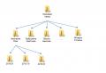
The logical structure of the GIS is shown in Figure 1.
General requirements
1) The information support of the GIS must be sufficient to perform all the functions of the GIS.
2) The set of information arrays of the system should be organized in the form of databases.
Requirements for the composition, structure and methods of organizing data in GIS
The composition and structure of the data must correspond to the information model developed in the system project.
Requirements for control, storage and updating of data
1) The system must, periodically, check the integrity of the state of the GIS databases by embedded software.
2) Modification of data structures should be carried out taking into account the conversion of real data previously loaded into the database in accordance with the changed data structure.
3) Any change in database structures should not lead to the loss of information that exists in the GIS.
Requirements for the language of interaction with GIS users
1) The linguistic support of GIS should be reflected in the documentation (instructions, descriptions) of the organizational support of GIS in the form of rules for the user to communicate with the GIS in all modes of its operation.
2) The interface of communication between the user and the GIS must be Russian-language (with the exception of specialized terms and commands).
4.3.3. Software requirements
General requirements
1) The GIS software must be sufficient to perform all the GIS functions, as well as have the means of organizing all the required data processing processes, allowing timely performance of all the GIS functions in all regulated modes of the GIS operation.
2) GIS software must have the following properties:
· Functional sufficiency;
· Reliability (including recoverability, availability of error detection tools);
· Adaptability;
· Modifiability;
· Ease of use.
3) GIS software should be built in such a way that the absence of separate data does not affect the performance of GIS functions, in the implementation of which these data are not used.
4) The GIS software must implement measures to protect against errors in the input and processing of information to perform the functions of the GIS.
5) The software should be composed of general and specific software (OPO and SPO).
6) OPO and open source software should be based on licensed software products.
General software requirements
1) OPO GIS should be unified and ensure the creation and support of a unified information environment for solving information, reference and search tasks of users.
2) OPO should support the creation of AWPs for GIS users, database servers, application servers, and also provide connection of individual technical means for various purposes.
3) OBO should include:
· Operating systems for workstations and servers for various purposes;
· Means of local and remote information exchange using a unified interface for access to services of information exchange subsystems;
· Means of administration, management and audit of the GIS hardware and software environment;
· Tools for testing, diagnostics and anti-virus protection;
· Means of processing textual, tabular and graphic information;
· Means of information protection from unauthorized access.
Dedicated computers (servers) must have the following software installed:
· Operating system of the Window Server family (with the IIS component on the web server).
Client workstations must have the following software installed:
· Russian-language operating system;
· Web browser with support for Flash technology.
The administrator's workplace must have an operating system installed at least Window XP SP 2.
Note 4 : The list of OPO products can be updated in the process of GIS development, as well as when more promising products appear.
5) The local network must provide data exchange based on TCP / IP protocols.
6) When forming an OBO, the issues of organizing interaction with already existing databases should be worked out.
Requirements for special software
1) Open source software should ensure the solution of functional and special technological problems, including manipulation with cartographic databases
2) STR should include:
· On the ArcGIS Server server, standard and specialized services that implement the functions of the user's workstation and one of the industrial DBMS (Oracle, MS SQL Server, etc.);
· At the workplace of the ArcGis Desktop administrator (ArcInfo with plug-ins);
· Open source software for working with GIS is not installed on client workstations.
4.3.5. Requirements for technical support
1) The GIS hardware must be sufficient to perform all the GIS functions.
2) The GIS hardware must comply with the requirements of the GIS software.
3) GIS technical support should ensure the required reliability of the GIS operation and data availability.
4) In the complex of technical means of GIS, technical means of serial production should be mainly used. If necessary, the use of technical means of a single production is allowed.
5) GIS technical means must be placed in compliance with the requirements contained in the technical, including operational, documentation for them, and so that it is convenient to use them during the operation of the GIS and perform maintenance.
6) The placement of technical means used by GIS personnel in the performance of their duties must comply with the requirements of ergonomics: for production equipment in accordance with GOST 12.049-80, for visual information presentation means in accordance with GOST.
7) Any of the GIS technical means must allow its replacement by a device of similar functional purpose, without any design changes or adjustments in the rest of the GIS technical means.
8) For each of the technical means of the system, the operating conditions specified in the operational documentation must be provided, if necessary, power supply, power, air conditioning, etc. systems should be deployed.
9) GIS technical means may be used only under the conditions specified in the operational documentation for them.
10) The power supply of the server equipment must ensure a regular shutdown of the server with data retention. The regular shutdown time is determined in the operating documentation for the software and hardware of the server equipment.
11) The GIS hardware must contain the means reserve copy to ensure prompt recovery of information.
4.3.6. Requirements for organizational support
General requirements
1) The organizational support of GIS should be sufficient for the effective performance of the GIS personnel of the duties assigned to him in the performance of GIS functions.
2) The organizational support of GIS should be fixed in the corresponding instructions for the organizational support of GIS.
Requirements for the content of instructions for organizational support of GIS
GIS organizational support instructions should:
1) Describe all modes of GIS operation.
2) Determine the actions of the GIS personnel necessary to perform each function in all modes of the GIS operation, taking into account the specified requirements for the accuracy and speed of implementation by the GIS personnel of their functional duties.
3) Describe the methods of diagnostics by the GIS service personnel of the onset and predicted failures of the GIS performance.
Requirements for documenting instructions for organizational support of GIS
GIS organizational support instructions should be documented.
4.3.7. Metrological support
There are no special requirements for metrological support.
5. The composition and content of work on the creation (development) of the system
5.1. GIS implementation stages
When creating a GIS, the following stages should be implemented.
5.1.1. Stage "Terms of Reference"
Table 5.1 shows the work to be done at the stage of "Terms of Reference".
Table 5.1. Works at the stage "Terms of Reference"
|
Job title |
Responsible |
Result |
|
|
Definition and analysis by the Contractor of the Customer's requirements for GIS |
Executor | ||
|
Development by the contractor with the participation of the Customer of the Terms of Reference for GIS |
Executor |
Technical task |
|
|
Coordination of technical specifications |
Customer |
Notes to the terms of reference |
|
|
Changes to the terms of reference |
Executor |
Terms of Reference agreed by the Customer |
|
|
Terms of reference approval |
Customer |
Terms of Reference approved by the Customer |
The implementation period is 1 month.
5.1.2. Stage "System project"
Table 5.2 indicates the work that must be performed at the stage "System project".
Table 5.2. Works of the stage "System project"
|
Job title |
Responsible |
Result |
|
|
Development of design solutions for GIS |
Executor |
Functional model and information model GIS data |
|
|
GIS database development |
Executor |
Logical and physical model GIS DB. |
|
|
Development of design solutions for GIS in general and by types of support, registration of a system project |
Executor |
System project |
The implementation period is 2 months.
5.1.3. Stage " GI developmentFROM »
Table 5.3 shows the work that needs to be done at the stage "Working design".
Table 5.3. Works of the stage "Development of GIS"
|
Job title |
Responsible |
Result |
|
|
Implementation of design solutions for the creation of GIS |
Executor |
Prototype GIS |
|
|
Development and testing on the Contractor's hardware of a prototype GIS |
Executor |
Prototype GIS |
|
|
Customer | |||
|
Deployment of GIS on customer hardware |
Executor |
GIS installed on the Customer's hardware |
|
|
Development of working documentation for the first stage of GIS |
Executor |
Working documentation listed in p. 1-4 p. 8.2.3. |
|
|
Development by the contractor of the Program and methodology for testing GIS (hereinafter in this section "Program") |
Executor |
Test program and methodology for the first stage of GIS |
|
|
Program approval |
Customer |
Program Notes |
|
|
Making changes to the program |
Executor |
Program agreed with the Customer |
|
|
Program approval |
Customer |
Customer approved program |
The implementation period is 5.5 months.
5.1.4. Stage "Putting into trial operation"
Table 5.4 indicates the work that must be performed at the stage "Putting into trial operation".
Table 5.4. Works of the stage "Putting into trial operation"
|
Job title |
Responsible |
Result |
|
|
GIS preparation for the start of trial operation |
Contractor (together with the Customer) | ||
|
Executor | |||
|
GIS testing |
Customer (together with the contractor) |
Prototype GIS |
|
|
Acceptance of GIS for trial operation |
Customer |
The implementation period is 1.5 months.
6. Procedure for GIS control and acceptance
6.1. General requirements
1) Acceptance of GIS for trial operation should be carried out at the Customer's facilities.
2) Acceptance of GIS for trial operation should be carried out in accordance with the guidelines listed in the next section.
6.2. Guidance documents
The following documents should be developed:
1) Program and methodology for testing GIS.
2) Draft program of trial operation, which should indicate:
· Conditions and procedure for the functioning of the system;
· Regulations for the contractor to keep a register of the Customer's comments and suggestions related to the operation of the GIS in the process of trial operation;
· Regulations for eliminating deficiencies identified in the process of trial operation;
· Requirements for the Customer's hardware required for testing and trial operation.
6.3. GIS verification procedure
6.3.1. Acceptance of GIS for trial operation
1) Based on the results of GIS tests carried out in accordance with the test program and methodology, a preliminary test report is drawn up, in which the compliance of the implemented system functions with the TOR requirements is recorded.
2) If the protocol reflects the possibility of accepting the system for trial operation, the acceptance commission draws up an acceptance certificate for trial operation, on the basis of which the GIS is accepted for trial operation.
6.3.2. Trial operation
1) In the process of trial operation, the Customer must keep a journal of comments and suggestions (the form of the journal of comments and suggestions and the rules for working with it are developed by the contractor). The customer should separate comments and suggestions to the declared GIS functions and all other comments.
2) Comments and suggestions to the declared GIS functions must be eliminated by the Contractor within the time frame agreed with the Customer.
3) After the contractor eliminates the comments to the declared GIS functions, a joint act on the completion of the trial operation and the commissioning of the GIS into commercial operation should be prepared
7. Composition and content of preparatory work
The section contains a list of the main activities and their performers that must be performed when preparing an automation object and putting the GIS into trial operation. All activities are grouped into three main areas, designed as subsections of this section.
7.1. Preparing information
Table 7.1 shows the work on the preparation of information for loading into the GIS.
Table 7.1. Information preparation activities
|
Name of the event |
Responsible |
Note |
|
|
Creation of a cartographic and attributive GIS base. |
Executor |
· Nodes of connection to FOCL; Operator coverage areas cellular communication; · Nodes of connection to WI-FI. 2.thematic linking of FOCL technological schemes to map objects, etc. |
|
|
Clarification of the cartographic and attributive GIS base. |
Executor |
Includes: 1. Clarification of the location and characteristics of objects on maps: Base stations; Television and radio transmitters, etc. 2. Correction of the cartographic database according to the specified coordinates of the objects. |
|
|
Organization of interaction between GIS and information and reference systems of the Ministry of Telecom and Mass Communications of the Republic of Belarus |
Executor |
Filling the GIS database with attributive information and connecting to information and reference systems used in the Ministry of Telecom and Mass Communications of the Republic of Belarus. |
7.2. Technical preparation of the automation object
Table 7.2 shows the work to ensure the technical readiness of the automation object.
Table 7.2. Measures to ensure the technical readiness of the automation object
|
Name of the event |
Responsible |
Note |
|
|
Providing the Contractor with hardware and software for GIS deployment |
Customer | ||
|
Ensuring technical readiness of hardware and software for GIS deployment |
Customer | ||
|
Installing system-wide software |
Customer | ||
|
Purchase and installation of applied software necessary for the functioning of GIS |
Customer |
Together with the Contractor |
|
|
GIS deployment |
Executor |
Together with the Customer |
7.3. Organizational activities
Table 7.3 shows the organizational measures necessary for putting the GIS into trial operation.
Table 7.3. Organizational activities
|
Name of the event |
Responsible |
Note |
|
|
Training of the Customer's personnel to work with GIS |
Executor |
8. Requirements for documentation
8.1. General requirements for documentation
1) Documents must be submitted by the contractor to the customer on paper in one copy (original) and on a magnetic medium in one copy (copy). Source codes of programs should be submitted only on magnetic media (original). It is possible to provide a set of documentation and program texts on CDs.
2) Text documents must comply with the Contractor's internal standard for paperwork.
3) It is allowed to issue documents using development automation tools (CASE-tools), agreed with the Customer.
4) All documents must be issued in Russian. Individual documents, including those issued using CASE-tools, may contain records in Latin letters (names of database fields, program text, etc.).
5) The composition of documents for the general software supplied as part of the GIS must correspond to the set of the manufacturer.
8.2. List of documents to be developed
8.2.1. Stage "Terms of Reference"
Technical task
8.2.2. Stage "System project"
System project consisting of:
1) functional model;
2) information model;
3) the structure of the GIS database;
4) requirements for GIS.
8.2.3. Stage " GI developmentFROM »
1) Source codes of programs with comments.
2) User manual.
3) Administrator's Guide.
4) Instructions for configuration and installation (may be included in the administrator's guide).
5) Program and methodology for testing GIS.
Note 5 : Documentation for GIS components may be included as separate sections in GIS documentation as a whole.
9. Development sources
1) Vernikov G. Technological evolution of corporate information systems. Information Technology Center, http: // www. ***** / cfin / articles / kis_xml. shtml, 2001
2) Information technology. A set of standards and guidelines for automated systems (GOST 34.201-89, GOST 34.602-89, RD, RD, GOST 34.601-90, GOST 34.401-90, RD 50-34.698-90, GOST 34.03-90, R 50-34.119- 90). - M .: Ed. Standards, 1989.
5) GIS is the basis of modern information support in the management of geographically distributed systems. // Scientific problems of the fuel and energy complex of the Republic of Belarus: - Ufa, 1997.
6) Creation of spatial data infrastructure of the Republic of Bashkortostan based on geoinformation technologies //, / Ufa: USPTU, 20s.
7) Citywide GIS. / // ArcReview, "Municipal GIS", №3 (46), +, 2008. - С.1-3.
8) The use of geoinformation technologies to create a spatial data infrastructure of the Republic of Bashkortostan //, / Geoinformation technologies in the design and creation of corporate information systems // Interuniversity scientific collection. Ufa: USATU, 2008. - C.56-c.
9) Multi-user processing of distributed-stored spatial information in scientific and educational GIS RB /, // Bulletin of USATU: scientific. zhurn. Ufimsk. state Aviation tech. un-that. Series "Management, Computer Engineering and Informatics". 2009. T. 12, No. 1 (30). S. 3–8.
10) Instructions for topographic surveys in M \u200b\u200b1: 5000,1: 1000, 1: 500 GKINP. Moscow, "Nedra", 1982
11) "Instructions for the development of survey substantiation and shooting of the situation and relief using global navigation satellite systems", GLONASS and GPS ", Moscow, TsNIIGAiK, 2002.
12) Shekhar, Sh. Basics of spatial databases / Sh. Shekhar, S. Chaula; per. from English. .- M.: KUDITS-OBRAZ, 2004 .- 336 p.
13) Seiler, M. Modeling Our World: ESRI's Guide to Geodatabase Design / M. Seiler: ESRI Press, p. 254.
14), Tikunov. - M .: Academy, 2005 .-- 480 p.
15), Tsvetkov. - M .: MAX PRESS, 2001.
16) ArcGIS 9. Geoprocessing in ArcGIS: GIS by ESRI.- M.: Date +, 2004 .- 358 p.
17) Tomlinson, Roger F. Thinking about GIS. Planning Geographic Information Systems: A Manual for Managers. Per. from English. - M. Date +, 2004 .-- 325 p.
eighteen) , . Data protection of geographic information systems Publisher: Helios ARV, 2010 336 pages.
19) , . Geographic Information Systems Publisher: KUDITS-Press, 2009 272 pages
20) Kang-Tsung Chang. Introduction to Geographic Information Systems. McGraw-Hill Higher Education, 2006 .-- 450 p.
21) Peters D. Building a GIS: system architecture design strategies for managers / ESRI Press, 2008, 292 p.
Introduction
Geographic information system (GIS) is an information system that provides collection, storage, processing, analysis and display of spatial and related nonspatial data, as well as obtaining information and knowledge about geographic space on their basis. It is believed that geographic or spatial data constitutes more than half of all circulating information used by organizations engaged in various activities in which it is necessary to take into account the spatial distribution of objects. GIS is focused on ensuring the possibility of making optimal management decisions based on the analysis of spatial data. Key words in the definition of GIS are - spatial data analysis or spatial analysis.
In this work, consider:
- - GIS in railway transport management;
- - Requirements for geographic information systems;
- - Characteristics, areas of application and basic capabilities of a GIS application.
The theoretical side of the issue
GIS requirements
At the moment, GIS is a complex information system that includes a powerful operating system, user interface, systems for entering databases (DB), displaying graphical information.
The development of geoinformatics as a science of automated processing of spatially coordinated information has led to the intensive promotion of geographic information systems and GIS technologies in all spheres of human activity.
At present, GIS should not be interpreted as geographic information systems, as geographers urge us to do. The importance of GIS in technical applications as information and control systems is much more promising.
The concepts of geographic information systems and their role in science and technology largely coincide, which, of course, is reflected in the formulation of the basic concepts and definitions of geographic information systems of railway transport.
GIS of railway transport is an information and control automated system designed to ensure the solution of problems of inventory, design and management of railway transport facilities. The main goal of creating a GIS for railway transport is to provide all spheres of its activity with complex spatially coordinated information.
Powerful GIS shells allow you to integrate any database and existing automated inventory, design and management systems. In turn, the information obtained as a result of GIS work is successfully used in automated systems inventory (certification), design (CAD) and management (ACS).
Along with GIS, the organization of problem-oriented databases designed for mapping natural and socio-economic phenomena has become widespread. Such databases are called cartographic data banks (CDBs).
The most important function of the CDB is in the automated mapping performed by the automated cartographic system, which is also an integral part of the GIS.
In recent years, when creating information systems (IS) in geography, increased attention is paid to the construction of expert systems (ES). ES is understood as a logical inference system based on facts (knowledge) and heuristic techniques (rules of thumb) for data processing.
The main components of the ES: knowledge base - organized sets of facts, a mechanism for the logical solution of the task.
The emergence in recent years of mass interest in the construction of GIS requires the development of principles for assessing the created information systems, their classification, and determination of potential capabilities.
To a certain extent, this is possible when developing requirements for an ideal GIS:
- 1. Possibility of processing arrays for component heterogeneous spatially coordinated information;
- 2. Ability to maintain databases for a wide class of geographic features;
- 3. Possibility of the interactive mode of the user;
- 4. Flexible system configuration, the ability quick setup systems for solving various tasks;
- 5. The ability to "perceive" and process the spatial features of geoecological situations.
The stages of information technology in the creation and operation of GIS include the following stages: collection of primary data, data entry and storage, data analysis, scenario analysis and decision making. It should be noted that the highlighted stages are the most general and are repeated when creating specific GIS, differing in details related to the goals and objectives of the GIS, as well as technical capabilities systems. Obviously, the sources of information, the procedure for obtaining it, methods of analysis should be considered as stages of a single technological process, united by the common goals and objectives of building and operating a GIS. This means that the design and creation of GIS should be based on a single methodology. Since GIS can be considered as a means of machine representation of data and knowledge of a complex of earth sciences, the direction of their construction as a toolkit for understanding the patterns of structure and organization of geosystems using informatics means, including mathematical modeling and computer graphics, should be chosen as the methodological basis of GIS.
- 1. The concept of information technology and information systems. Modern concepts, ideas and problems of information technology development. The role and objectives of information technology in the development of society.
- 2. The concept of information, message, signal, coding and modulation. Generalized information transmission system and the purpose of its main elements.
- 3. Conversion of continuous signals into discrete ones, their transmission in the form of digital signals.
- 4. Fourier series for a periodic sequence of pulses and its power. Amplitude-frequency (AFC) and phase-frequency (FFC) characteristics of a periodic sequence of pulses.
- 5. (Spectral density s (w)) for a non-periodic signal. Direct and inverse Fourier transform.
- 6. Discretization of signals in time. Kotelnikov's theorem.
- 8. An absolute method for determining coordinates in satellite technologies. Pseudorange intersection. The precision of the absolute method. Geometric factors dop.
- 33. Model of interconnection of open systems (Open System Interconnection, osi). Standard communication protocol stacks. Implementation of internetworking by means of tcr / ip.
- 34. Communication devices of the information network. Data transmission medium. Standard technologies for building local and global networks.
- 35. Methods of switching in information networks (channel switching, packet switching, message switching).
- 36. The level of interconnection (Network layer), its purpose, functions and protocols. Principles of routing in composite networks.
- 37. Corporate information system (kis). Requirements for corporate IP. Implementation problems. Examples of kitties.
- 38. Ensuring information security in modern corporate networks. Methods of protection against unauthorized access. Technologies: Intranet, Extranet and vpn.
- 13. Protection of applications and databases. The structure "user (group) - right". Role model for organizing access rights. Organization of access to the subdivision "client-server".
- 14. Secret communication systems. General structure, principle of operation. The strength of the encryption algorithm. Shannon's theory.
- 15. Cryptographic methods of information protection, their classification. Requirements for cryptographic information closure. Encryption standard (general description of the des algorithm).
- 16. The concept of public key cryptosystems. Electronic digital signature. Structural diagram of the EDS construction.
- 17. Destructive software: computer virus (classification, signs of infection, methods of detecting and neutralizing the virus).
- 18. Methods of protecting IP from unauthorized access at the logical, physical and legal levels. Russian legislation in the field of information protection.
- 19. Protection of information on the Internet. Purpose of shielding systems. Requirements for the construction of shielding systems. Organization of security policy in Internet networks.
- 23. Interfaces is. User interface is.
- 24. Reliability of is. Factors affecting the reliability of IC Methods for increasing the reliability of is.
- 25. Structural approach to the design of information systems is.
- 26. Life cycle of software (life cycle software), model life cycle.
- 27. Case-technologies as new means for designing is. Case-package of platinum firm, its composition and purpose. Criteria for evaluating and choosing case-tools.
- 28. The idef standard, its main components.
- 29. Principles of systemic structural analysis, its main aspects.
- 30. The bpWin tool environment, its purpose, the composition of the models, the package's capabilities. Composition of reports (documents) of the designed model in the bpWin environment.
- 31. The erWin tool environment, its purpose and the composition of the tasks to be solved.
- 32. Unified modeling language uml, its purpose, the composition of the tasks to be solved with its help.
- 39. Databases (DB). The main stages of database development. Methods for creating a database structure. Data types. Structured data.
- 40. Data models used in databases. Links in models. Database architecture. Relational, hierarchical and network data models. Data types and formats.
- 41. Database management systems (subd). Purpose, types and main functionality of subd. Review of existing subd. Subs composition, their performance.
- 43. Standard sql query language. Sql queries to get information from the database. Basic principles, commands and functions of building sql-queries.
- 44. Modifying data using sql query language. Creating and changing the structure of tables. Adding and editing data. Search and sort data based on sql.
- 45. Data normalization. First, second, third are normal forms. The procedure for converting data to normal form.
- 46. \u200b\u200bGive the concepts of primary key (pk), foreign key (fk), alternative key, inverse input. Types and organization of relationships between tables.
- 49. Systems of artificial intelligence (AI). Classification of the main directions of research in the field of ai.
- 1.2.3. Development of natural language interfaces and machine translation (natural language processing)
- 1.2.4. Intelligent robots
- 1.2.5. Training and self-study (machine learning)
- 1.2.6. Pattern recognition
- 1.2.7. New hardware platforms and architectures
- 1.2.8. Games and machine creativity
- 50. Expert systems (ES), composition of the ES. Classification of ES, their structural composition. ES development tools.
- 51. Models of knowledge representation (production, frame, network model).
- 52. Classification of systems based on knowledge.
- 2.2.1. Classification by the problem being solved
- 64. Digital terrain models (dsmm), digital models of the situation and relief, digital models of the map and plan. Layers dmm. Purpose and use of digital and electronic maps and plans.
- 65. Raster and vector form of data presentation. The formats of this data. Registration of raster images in cartographic systems.
- 67. Modern technologies for creating digital and electronic maps and plans. Classification of object types when digitizing (vectoring) maps. Topographic information classifiers.
- 68. Programs - vectorizers, their characteristics, principles of work and capabilities. Methods and precision of vectorization. Analysis of the quality of vectorization. Control of the topological structure of a digital map.
- 53. Essence and basic concepts of geoinformatics. Application areas of geoinformatics.
- 55. Topological concept of gis. Georelational model of communication between objects and their attributes.
- 57. GIS creation tools (MapEdit, MapInfo, GeoMedia, etc.). The main functions, characteristics and capabilities of gis - shells. Tools for expanding gis-shells and creating applications.
- 58. Federal, regional and municipal gis. Requirements for software and information support of gis.
- 60. Spatial (geographical) analysis. Buffer zones, overlays. Creation of thematic maps based on gis - technologies.
- 61. Method of surfaces for creating thematic maps. Interpolation based on an irregular network of triangles tin and a weighted average idw.
- 53. Essence and basic concepts of geoinformatics. Application areas of geoinformatics.
- 63. Geoinformation modeling. Fundamentals of network analysis.
- 64. Computer-aided design systems (cad - MicroStation, AutoCad, etc.). Basic concepts of two-dimensional (2d) and three-dimensional (3d) design. Gis connection with cad - systems.
- 21. Improving the reliability of systems through redundancy. Types and methods of reservation.
- 62.3D maps. Ways to create and use 3D maps.
- 9. Differential method for determining coordinates. Types of transmission channels for differential corrections. Differential correction methods. Differential correction system waas. Dgps accuracy.
58. Federal, regional and municipal gis. Requirements for software and information support of gis.
FSIS, MGIS, RGIS - designed to solve operas. and computational tasks related to the processing of spatial GIS data in management, planning inventory, monitoring, analysis and forecasting. spatial data used in GIS should cover:
1 for FSIS - all territories of the Russian Federation, including coastal waters and border areas.
2 for RGIS - territories of large natural and ecological regions of the constituent entities of the Russian Federation, Fed. districts including areas of protected areas, areas of crisis situations.
3 for MGIS - territories of cities, urban areas, suburban areas
Requirements for software and IO for GIS
For the formation of DB, F, R, MGIS, GIS: 1) basic digital terrain model (for FGIS - ctk m - 1: 1,000,000; for RGIS ctk of scale 1: 50,000 - 1: 200,000 and ctg of scale 1: 500 - 1: 1000 for MGIS ctg scale 1: 500 - 1: 10000). 2) digital thematic specificity of the map. 3) aerial and satellite images in digital format. 4) thematic data. 5) attribute data. 6) metadata. 7) regulatory information. In the terms of reference for a specific GIS, the requirements for the IO are established in terms of: 1. composition, structure, ways of organizing these systems. 2. to the quality of data (completeness, reliability, relevance). 3. availability of a certificate of conformity. 4. compatibility of essential and created components. 5. the use of a DBMS. 6.organization of information exchange with other bases. 7. processes for collecting, processing and transferring information 8. control, storage and updating of recovery for. 9.Provides documentation management
10. The procedure for giving GIS software by legal means should include the following: - operating system. - text and graphic editors. –Special software composition. - software library, a set of applied programs.
The software supports the main GIS systems.
Collection, data entry; - storage.
59. The main stages of creating gis - projects. Sources of data for the formation of graphic and attributive (non-graphic) information.
Main steps:
1. Development and approval of a business plan (here the financial and economic aspects, the expected result, sources of financing, terms, costs are discussed). 2. Conclusion of the contract (here is the protocol of the negotiation of the contract price). 3. Development of technical specifications is a document that contains the requirements that b. are real. 4. Approval.
5.Technical design (finding a technical solution)
Statement of tasks (input output information). -Development of a conceptual model (draw information model of each task). -Technical solutions (algorithm). 5. Development of working documentation - Operational documentation of how to use the system - Network diagram. -Database projects.
Development of programs and methods for preliminary tests.
7. Three stages of testing the system: 1. Preliminary test - checking the system performance, are carried out on the basis of development. The developer must put the conclusion whether the system is working or not. - whether the system can be transferred to the next stage or not. 2.Experienced operation. Determination of the quantitative characteristics of the system, lasts at least 6 months. To carry out a trial operation, a special program is drawn up, carried out on the basis of a problem book. pilot operation is carried out by the pilot project. This is a production work in which production results will be obtained, but they will be performed within the constraints: territory, function. In the log, we see everyday entries: what tasks were solved, failures, whether the program worked or not. At this stage, corrections are made along the way. At the end, an act of reconciliation is written whether the stage has been completed based on the journal. Conclusion: - consider whether the trial operation is completed. - is it possible to transfer the system to the next stage. 3. Acceptance testing is carried out by the customer's tests, the commission is usually taken from outside. Purpose: compliance with TK may partially correspond to TK. After these stages, an act of acceptance of the system of permanent operation is drawn up. Conclusion: The system as a whole complies with the TK. If it does, then the system can be transferred into permanent operation or not. After starting, the system enters the operating phase. There are 3 main processes going on here: -Performance of administrative work to ensure the system. -Database introduction. -Solution of spatial problems by the end user. Data sources: topographic and geodetic data;
coordinates of points; measurement results; CMM;
cartographic materials (paper maps, aerial photographs, space photographs);
attributive information (characteristics of objects, cadastral data)
1.2 GIS structure and its main functions
In its most general form, the GIS structure can be represented as follows (Fig. 1): dialogue system user software and hardware complex, databases, block of models,
block of assessment and decision making. GIS construction is carried out according to the block (model) principle. This makes it possible to expand the system by adding new blocks (programs) or to work only with a certain part (module) of the GIS.
Figure: 1. GIS structure
Multipurpose GIS can be used for a variety of tasks. The fulfillment of the tasks being solved is associated with the implementation certain functions... So, along with others, GIS performs the following main functions: preparation and maintenance of data banks; information and reference; simulation modeling; expert modeling; automated mapping.
GIS can be considered as an information basis (database) for studying the natural features of a region and as a tool for studying dynamics or forecasting phenomena and processes (a system of models).
In addition, GIS can be used as an information and reference system that searches and selects data based on a specific request. The next moment of GIS work is associated with the development of mathematical models or a system of expert assessments in order to analyze the dynamics of geosystems.
To solve each of the listed tasks, it is necessary to develop algorithmic and software, as well as create interactive human-machine systems that support the user's work and the presentation of modeling results in a traditional cartographic form.
Software and hardware complex. At the moment, GIS are completed as graphic stations using various means of input-output of graphic information. The organization of regional GIS requires a computer with a sufficiently large amount of RAM and significant speed, working both in interactive and batch mode... For this purpose, both large computers (for processing space information) and personal computers can be used.
Graphical information input devices are divided into automatic (scanners) and semi-automatic (digitizers). To build cartographic images are used: plotters, matrix printers, color inkjet printing devices. The graphics system also includes a color graphics display that provides an interactive user experience.
Information block (databases). Information arrays in GIS are combined into databases, access to which is provided by a DBMS. The main purpose of databases is to serve the information needs of the user, as well as to support the system of GIS models. The database stores not only factual information at a certain point in time, but also the initial conditions and coefficients of the model equations used in the simulation mode.
Various user query commands are used to search and retrieve data. Using or combining different commands makes it possible to present query results in various forms: tabular, graphic, cartographic. Depending on the request, the actual information can be supplemented with statistical parameters: mean value, variance, etc.
Model block. This block includes software designed for various data processing operations. Since the GIS is built as a multipurpose and multifunctional information-modeling system, it includes software packages, as well as a bank of standardized models.
The central place in GIS is occupied by an automated mapping system. When organizing GIS, ready-made models or program blocks can be used that meet the requirements of the tasks being solved. Standardization of particular models that simulate individual properties of the landscape or its components (soil, vegetation, migration of substances in the landscape) simplifies the procedure for providing information to the models, and most importantly, makes it possible to use the existing experience in modeling specific processes in the landscape when solving new problems.
An important place in GIS is given to the block of expert modeling and expert assessments. In this part of GIS, the leading role is assigned to an expert, a specialist in a specific subject area. The work of this GIS subblock is to automate traditional methods of analysis and synthesis of geocological information, performed by an expert based on a set of rules of thumb.
User dialogue management system. The functioning of GIS as an integral system is provided by the user dialogue management system. This block implements the relationship between the individual GIS subsystems, organizing the dialog interaction of the user with the system. Depending on the problem being solved, the GIS is automatically configured to solve it. For this, the required model is selected from the bank of models, and all the necessary data from the information block.
The GIS dialog mode is designed for users of various degrees of training: applied programmers, analysts and researchers, and casual users. For each type of user, its own level of dialogue is selected.
Assessment and decision making unit. The results of GIS work are analyzed in the block of assessment and decision making. It should be noted that the user dialogue control system is inextricably linked with the assessment and decision-making unit through the formation of a set of scenarios, the choice of display methods (tabular, cartographic) of the results obtained.
The evaluation unit, like the dialog system, is designed for various GIS operation modes. The simplest one is the use of GIS as an information and reference system, the more complex one concerns the development of an automated methodology for analyzing the results of simulation modeling.
The choice of scenarios is directly related to the assessment of geoecological situations and is largely based on the expert's knowledge of the most typical or probable conditions for the behavior of the studied natural object under the influence of disturbing factors.
In modern systems for monitoring and managing the quality of the environment, an important place is occupied by the promptness of obtaining the results of machine forecasting. The decision maker is required to review various modeling scenarios in a short time, analyze the results obtained and propose the most optimal management solutions based on the results of the GIS models.
2. Databases
Large volumes of primary geoinformation registered as four levels of observation require the organization of their storage in the memory of micro-, mini- and supercomputers according to special rules and principles that allow multiple access to them in order to use the data for processing and interpretation, choosing a strategy for further prospecting and prospecting or exploration and operational work, making optimal management decisions based on the results of processing and interpretation.
At the same time, it is important that the organization of data and their storage in various technical means [micro-computers ("Iskra", "Electronics", IBM, etc.) in the mode personal computer, mini-computers (SM computer, BVK (SM-1), control computer complexes UVK (SM-2, SM-4, SM-1420, CM-1810, etc.), as well as super-computers (expeditionary computing complexes EGVK PS-2000 and SM-2, EC-10/55, etc.)] were distinguished by a single technology, ensuring the possibility of their use for solving various geological problems, taking into account the difference in technical means. Consider the concepts of a database, various types of databases and their interaction between yourself.
Internet Explorer - creation of web pages
To download IE, you need to click on the icon on the Windows 98 desktop, or download it from Start Programs Internet Explorer Internet Explorer. After loading, the IE shell appears on the computer monitor. Back (1) and Forward (2) buttons ...
Automated warehouse management information system
Let's highlight several main functions: 1) Converting the production assortment into consumer assortment in accordance with demand. This function is of particular importance in distribution logistics ...
Basic concepts and definitions of computer science
Technical means are intended for the operation of the information system ...
Data verification
The header file "Fdstat.h" implements several functions for processing and visualizing data, as well as declaring three variables in the global scope ...
Integration of EDMS based on typical subsystems
The construction of workflow automation systems from existing products on the market requires not only a good understanding of the final task, but also an excellent knowledge of the software market ...
Information system of multiuser systems
The logistics function is an enlarged group of logistics operations that are homogeneous in terms of the purpose of these operations and differ significantly from another set of operations. The classification of the main functions of logistics is shown in Table 1 ...
Software classification
Loading programs into RAM and executing them; - standardized access to peripherals (input-output devices); - management rAM (distribution between processes ...
Logical foundations of digital devices
A logic gate (gate) is a part of an electronic circuit that implements an elementary logical operation, thus converting a set of input logic signals into an output logic signal ...
Multidimensional unsteady heat conduction problems. Examples of implementing a difference solution in environment X
LinearSolve (M) - a function that solves an algebraic system of equations (matrix M) surfdata (g, r1, r2, options) - creates a 3D surface using the input data g - a matrix of values, r1, r2 - a range of selected values. 4...
Description of the implementation of the base model electrical circuit
MathCAD is an integrated programming system focused on mathematical and engineering calculations. The MathCAD system contains a text editor, calculator and graphics processor ...
Applied Aspects of Information Technology
Designing the database "Law Office"
The main functions of the governing bodies are making changes and additions to the Charter of the organization, approving internal documents, attracting new clients, preparing case documentation for the trial ...
Designing a database and database management systems in Microsoft Access
1. Organization of data. Create and manage tables. 2. Linking tables and providing data access. Access allows you to link tables by matching field values, with the goal of later joining several tables into one. 3 ...
Database development for CMS online store
Providing tools for creating content, organizing working together over content, content management: storage, version control, adherence to access mode, document flow control, etc.
Development of an integrated information and analytical system for a dermatovenerologic dispensary
The first function is to directly manage data in external memory. This function of direct data management in external memory includes providing the necessary external memory structures for both data storage ...