How to add maps to the navigator navitel. Auto software: how to update maps in Navitel, Explay, Garmin, Prestigio navigators. Why you need to update maps in the navigator
Very often when using navigators, their owners are faced with the problem of updating maps. As a rule, the majority turn to either the firms that sell these devices, or to local “craftsmen” with a request to help in this matter. But with the right approach, money can be saved, because updating the navigator is not such a difficult business.
First, let's figure out which maps and for which navigators are most suitable.
On the market of navigators and navigation maps, there are now a lot of manufacturers who use third-party maps in their devices. If you buy a Prestigio or Prology navigator, the maps of the Navitel system will be preinstalled on them, but by purchasing the Garmin nuvi 1300, you will become the owner of maps developed specifically for this device, which will complicate the transition to maps and services of another manufacturer, although today all the developers for GPS are actively expanding the capabilities of devices and they are equivalent in functionality.
To update your navigator, you need a computer and a USB cable to connect your navigator to your computer. We load the map for the device to the computer, then connect the navigator and copy your maps to it. This procedure is slightly different for each manufacturer.
Let's start with devices controlled by Navitel software, as the most widespread and popular in the CIS.
Video tutorial on how to update Navitel on the car navigator and put new maps
The first thing to do is to download the website www.navitel.su last update cards from the manufacturer. To counter pirates who steal cards, the developers have implemented registration of each device, so you will need to register, after which from personal account download the update from the My Devices menu.
Choose the type of map depending on your navigator. Unpack the resulting file. We connect the navigator to the computer, go into its memory, cut out all the old maps to the computer, fill in new maps instead. Disconnect the device from the computer and launch the Navitel program. If you did everything correctly, then the program itself will find the map files and launch them. Sometimes you need to create a map for a specific region, but you will also need maps installed on your navigator.
In this case, create a folder with any name on the USB flash drive from your navigator, for example, Home.
We load maps into this folder, insert the USB flash drive into the navigator, and in the settings of the Navitel program, manually specify the path to the folder:
- Select "Open Atlas", click to create an atlas at the bottom.
- In the window that opens, indicate where our Home directory is located.
- Open the folder and click the "Create Atlas" button.
- We are waiting for the program to load the map, click on the checkmark.
- We mark the map in the list and use it.
The instruction refers to devices that work with Navitel cards. The most common navigators you will come across are Explay, Prestigio, Prology navigators.
Here comes the update garmin navigator goes a little differently. For proper installation, you need a utility from the manufacturer, called "Garmin Communicator", which is located on the official website:
- We go to the site and select the type of device.
- We connect the navigator.
- If necessary, we enter the serial number.
- Go to the search for updates, press the button "Find updates for maps".
Update types
NuMaps Guarantee ™ update for Nuvo, Zumu, Dezl devices:
- Go to www.garmin.com, go to the update section.
- We connect the device.
- Double click on "Update now".
- We determine with the format of your card.
- Click "Download".
- We save.
You need to install as follows:
- Launch the saved GarminMapsUpdate.
- If necessary, we go through the update procedure.
- After adopting " License agreement", Click" Continue "and follow the prompts that appear on the screen.
- If the update asks for a key, then enter the license number in the add key field.
To find out the license number, on the Garmin website in the Maps Updates section, select your navigator and click "content on device", copy and paste:
- We press the inscription "You can start updating the maps."
- We select the region of the map that we want to install. Don't be alarmed if the update takes a long time, sometimes a couple of hours.
It happens that there is not enough space to add new cards and the system will ask a question about cleaning the device. By checking the box next to "Save music and pictures to computer", you will save them to your computer.
Your attention may be drawn to the inscription "Installation options". In it, you decide which card should be updated or installed, and you can also specify the region that will be displayed on the device.
This method is quite difficult for a beginner, so Garmin has created a simpler and easy way... Garmin Lifetime Updater makes it possible to offline update maps.
The program itself constantly searches and updates maps depending on which maps are installed or on your location and updates them:
- Double-click on the "Garmin Lifetime Updater" installer launcher file with permissions or exe (or dmg, if you are a happy MacPc owner), then carefully read and follow the instructions.
- Add your device by clicking "add device", enter the name of the device, giving it a nickname.
- Click Add Device.
In the event that you already have an old version of the file installed, you will need to update the map.
Garmin Lifetime Updater has many settings that will make your life much easier later.
Let's dwell on them in more detail:
- "Devices". In this section, you can add or remove a device.
- "Timetable". Here you indicate after what period you need to update the maps.
- "Compound". If you have a connection through a proxy server, then write its settings in this paragraph.
- "Installation" is the most interesting section, your device can be updated immediately, or it is possible for the maps to be loaded onto the computer themselves, and then uploaded to the connected device. It is very convenient if you make money from it. A client comes in, and you have his navigator in the settings. Connect, and the update immediately began, without unnecessary movements.
- "About the program". Here, in addition to information about installed version, you won't find anything else.
Sometimes you will need a map that is not in your package on the navigator. Then you can go in two ways. The first one is correct, but expensive - using the nuMapsLifetime utility.
Connect the navigator to the computer, go to the Garmin website, then enter the serial number:
- Next to the desired card, click the item "Add to the list of selected goods".
- Follow all subsequent instructions.
The second method is illegal, but free. On the Internet, you are looking for maps, as a rule, along with them, there is a keygen, which will help you break the protection against pirates.
- Then we connect the navigator to the computer, before installing the SD card into it. Your navigator will now appear in My Computer as two new drives.
- We go to the USB flash drive (not in internal memory navigator), there we create a folder "Garmin", where we write down the downloaded files with maps and keys to them. It's two different files, one contains the map, and the second is generated using keygen. You can find how to create it in the archive with maps. The fact is that each keygen has its own instruction, which is, as a rule, in the readme file (opened with notepad). And the identifier number will help generate the key file for the map.
Another fairly new service of maps for navigators is "Cityguide". Maps work with both GPS and Glonas. Their peculiarity is that they are released free of charge, but with a trial period. Also, with the help of additional paid content, their capabilities are expanded. The maps are very convenient and accurate, they were developed by the Russian company "Mit" LLC.
In the free version, your navigator will only work for 15 days. But paid add-ons will make it just an amazing device that will show traffic jams, will be able to correct the map online with a change in traffic flow or new installed signs, indicate where road works are being carried out, and you will not need to update them.
All this is realized by involving all traffic participants in the service of informing others, you can mark problem areas on the navigator, which will transmit them to the server, where they will be marked and broadcast to other people. The software package implements the ability to communicate with friends through the built-in radio program, which has a separate channel on the Internet, and you can also see where they are at any time. But this is possible if their navigator has a "Citygid".
Another advantage of this system is the use of maps from the free OpenStreetMap project, which are adapted for this system. But paid features they do not work, except for some cards that can display traffic jams.
Installing the program is very simple: directly from the device we go to the program service (for example, GooglePlay or AppStore) and download it from there. Next, launch it and select the option to download the program, trial or paid. If you choose a trial, then your cards will be able to work only 15 days from the date of download and only if you have the Internet.
We install the cards using a computer:
- We go to the website www.probki.net.
- We enter the password and username obtained during the activation of the trial (you can find them along this path: Menu -\u003e Miscellaneous -\u003e Settings -\u003e Cityguide -\u003e Account).
- In the list "Your licenses" select a trial license, the first will be the letters TMPA, then the numbers.
- Go to the map section and select the card that we need, while hovering the mouse cursor over the word "date", as a result it will change to the word "download", and from the date the free time will start counting.
- In the panel that appears after "download", select the desired service and download it to your computer.
- We connect the navigator with via USB the cord that comes with the kit. Before that, you will need to change the operating mode of the device, see the instructions for the device.
- Select the SD memory card and copy the downloaded maps into it, into a folder on the navigator called CGMaps.
- Disconnect the navigator from the computer.
- We start the navigation program in the main menu of the navigator.
You can also install maps online from your device, if it has a high-speed connection. For this: - We select the menu "Download maps" along the path: Menu -\u003e Miscellaneous -\u003e Settings -\u003e Maps -\u003e Map manager.
- We select the necessary maps from the server, put a check mark.
- We confirm the download by clicking on the checkmark in the lower right corner. Downloading.
After downloading we get licenses - Go to: Menu -\u003e Miscellaneous -\u003e Settings -\u003e Maps -\u003e Map Manager -\u003e Map Licenses.
- We are waiting for the license activation.
If you receive a negative answer, then check if the username and password are entered correctly, as well as the Internet connection.
As with the rest of the navigation systems, the pirates also hacked the Cityigid, the most common cure for it is from the Freedom forum. The instruction is very simple:
- Loading the Frеdоm forum.
- We delete the CityGuide folder on the navigator, before that, be sure to save all bookmarks and other files on your computer.
- Download and run the installer with the .apk extension (for android OS), install it and close it immediately.
- Installing the Freedom forum.
- Launch CityGuide and download trial cards.
- When the download is complete, a buy message appears. By clicking on it, a message will appear that the application has been purchased. Congratulations, you are now a working paid card holder.
But this option does not always work, so there are already hacked programs for navigation. To replace it, simply erase the official one and replace it with the hacked one by pirates. The instructions follow.
Cityguide navigation software will work perfectly on all models of navigators from Explay, Prestigio and Prology. Even if you install them instead of those that were already there.
I would like to note that the maps from Navitel have all the features that Cityigid does, but at the same time some functions are implemented in them much more inconveniently than in navigation maps from Cityigid.
It is also worth considering another navigator and a set of navigation maps. It is called Shturmann. True, its developer has closed the project and they are no longer released. But the cards for him remained and, moreover, not bad ones. The easiest way with it is to run the Installer.exe file and all the maps are installed on the navigator, just do not forget to connect it to the computer first.
- news
- Workshop
Limousine for the president: more details revealed
The website of the Federal Patent Service continues to be the only open source of information about the "car for the president." First, NAMI patented industrial models of two cars - a limousine and a crossover, which are part of the "Cortege" project. Then the namishniki registered an industrial design called "Car dashboard" (most likely, namely ...
AvtoVAZ nominated its own candidate to the State Duma
The official statement of AvtoVAZ says that V. Derzhak has worked for over 27 years at the enterprise and has gone through all stages of career development - from an ordinary worker to a foreman. The initiative to nominate a representative of the workforce of AvtoVAZ to the State Duma belongs to the collective of the enterprise and was announced on June 5 during the celebration of the city of Togliatti. Initiative ...
Self-driving taxis to appear in Singapore
During the test, six modified Audi Q5s capable of autonomous driving will be launched on the roads of Singapore. Last year, such cars smoothly traveled from San Francisco to New York, Bloomberg reports. In Singapore, the drones will move along three specially prepared routes equipped with the necessary infrastructure. The length of each route will be 6.4 ...
The regions of Russia with the oldest cars are named
At the same time, the youngest car fleet is listed in the Republic of Tatarstan (average age - 9.3 years), and the oldest - in the Kamchatka Territory (20.9 years). Such data in its research are provided by the analytical agency "Autostat". As it turned out, apart from Tatarstan, only in two Russian regions the average age of passenger cars is less than ...
Private cars will be banned in Helsinki
In order to make such an ambitious plan a reality, the Helsinki authorities intend to create the most convenient system in which the boundaries between private and public transport will be erased, Autoblog reports. Sonia Heikkilä, a transport specialist at the Helsinki City Hall, said that the essence of the new initiative is quite simple: the citizens should have ...
How to properly respond to flooded streets. Video and photo of the day
The fact that this thesis is more than just beautiful words is clearly demonstrated by the videos and photos that appeared after the flood that occurred in Moscow on August 15. Recall that in less than a day, more than a monthly norm of precipitation fell on the capital, as a result of which the sewage system could not cope with the flow of water, and many roads were simply flooded. Meanwhile, how ...
Professor of Moscow State University will star in the new Pirelli calendar
Hollywood stars Kate Winslet, Uma Thurman, Penelope Cruz, Helen Miren, Lea Seydoux, Robin Wright took part in the filming of the cult calendar, and Moscow State University professor Anastasia Ignatova was a specially invited guest, according to Mashable. The shooting of the calendar takes place in Berlin, London, Los Angeles and the French town of Le Touquet. How...
The iconic Toyota SUV will sink into oblivion
The complete cessation of production of the car, which has so far been produced for the markets of Australia and the Middle East, is scheduled for August 2016, according to Motoring. For the first time the production Toyota FJ Cruiser was shown in 2005 at the International Auto Show in New York. Since the start of sales until today, the car has been equipped with a four-liter gasoline ...
Mercedes will release a mini-Gelenevagen: new details
New model, designed to become an alternative to the elegant Mercedes-Benz GLA, will receive a brutal appearance in the style of Gelendvagen - the Mercedes-Benz G-class. The German edition Auto Bild managed to find out new details about this model. So if you believe inside information, the Mercedes-Benz GLB will have an angular design. On the other hand, complete ...
New Kia sedan to be named Stinger
Five years ago, Kia unveiled the Kia GT concept sedan at the Frankfurt Motor Show. True, the Koreans themselves called it a four-door sports coupe and hinted that this car could become a more affordable alternative to the Mercedes-Benz CLS and Audi A7. And so, five years later, the Kia GT concept car morphed into the Kia Stinger. Judging by the photo ...
Review of the most popular crossovers and their comparison
Today we'll be looking at six crossovers: Toyota RAV4, Honda CR-V, Mazda CX-5, Mitsubishi Outlander, Suzuki Grand Vitara, and Ford Kuga. To two very fresh new products, we decided to add the debuts of 2015, so that the test drive of 2017 crossovers was more ...
HOW to choose a car for rent, choose a car for rent.
How to choose a car rental Car rental is a very popular service. It is often needed by people who have come to another city on business without a personal car; those who want to make a good impression with an expensive car, etc. And, of course, a rare wedding ...
All cars in the world can be divided into categories in which there will be an indispensable leader. So you can select the fastest, most powerful, economical car. There are a huge number of such classifications, but one is always of special interest - the most expensive car in the world. In this article...
HOW to choose a car brand, which car brand to choose.
How to choose a car brand When choosing a car, you need to study all the pros and cons of the car. Look for information on popular automotive sites where car owners share their experiences and professionals test new items. Having collected all the necessary information, you can make a decision in ...
Reliability of machines by ratingWhat are reliability ratings used for? Let's be honest with each other, almost every motorist often thinks: the most reliable car is mine, and it doesn't give me much trouble with various breakdowns. However, this is just the subjective opinion of each car owner. By purchasing a car, we are in ...
The cheapest car in the world - TOP-52018-2019
Crises and the financial situation are not very conducive to buying a new car, especially in 2017. Only everyone has to drive, and not everyone is ready to buy a car on the secondary market. There are individual reasons for this - who is not allowed to travel by origin ...
Rating of reliable cars 2018-2019Reliability is by far the most important requirement for a car. Design, tuning, any "bells and whistles" - all these ultra-fashionable tricks in their degree of importance inevitably fade when it comes to the reliability of the vehicle. The car should serve its owner, and not cause him problems with its ...
Luxury cars of the starsLuxury cars of the stars
Celebrity cars must match their star status. They simply cannot come in something modest and generally accessible. Their vehicle must match their popularity. The more popular a person is, the more sophisticated the car should be. Globally Popular Stars Let's start this review with ...
- Discussion
- In contact with
If you need to install maps on your Garmin navigator, then you've come to the right place. Below we will consider several ways to do this. So to speak, a small help - instructions for filling cards.
How to upload a map to your Garmin navigator using Map Source (instructions for use)
This is the easiest and most correct way. The instruction in this case is as follows:
Requirements:
To install in the navigator, you need MapSource, you can download it by. For Linux, QLandkarteGT can be used, but the result may vary.
Next, install the MapSource program.
- Download the archive with the map you need, for example.
- Unpack it with an archiver.
- Run the install.bat file.
- Launch MapSource and select the maps you need (Enable tool " Highlighting cards"on the toolbar).
- If you do not want to lose the maps that are currently in your navigator, download them to MapSource and save.
- We send the received set of cards to the device (Press the button " Send to device"on the toolbar) after connecting it to the computer.
- We use it.
====================================
You may need and will be useful like this instructions for installing maps on Garmin:
Unlocking GPS navigator Garmin
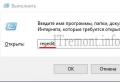
This method works for all versions of Garmin navigators, except for PC versions of the system; in the latter case, failures are possible. First you need to unlock the navigator. To do this, you need to find out your device ID. Just turn on your Garmin, select Tools, then go to Settings, and then select System. The top field will contain ID and many digital number... Copy it to your computer (eg notepad).
Then download KeyGen 1.5 (unlocker for Garmin) by this or this link.
After downloading the application, open it and enter your ID in the upper field (only numbers). Depending on the operating system enter your operating system type - Garmin Mobile XT or Garmin, then press Generate
.
Copy the code into the box Your software unlock code
.
In the folder window settings, configure the display of file extensions, this will come in handy later.
Then open notepad and paste the resulting code into the program window. Save the resulting file as sw.unl
... If the file is created like sw.unl.txt
then just delete (F2) unnecessary.
The resulting file must be placed in the Garmin folder. (folder X: / Garmin /
)
Disconnect and re-enable Garmin. We are now ready to install maps.

Installing maps on Garmin
The navigator itself is capable of working with four navigation maps. Each card should be renamed according to the principle:
Gmapbmap.img - usually, basemap.
- Gmapsupp.img - your map,
- Gmapsup2.img - your second map
- Gmapprom.img is your third card.
We will install one card in the review. To get started, connect your Garmin in data mode. Maps can be freely distributed in the form of several options:
1. As an EXE file
2. As an IMG file with a FID number.
3. In the form of an IMG file, already cured by the universal code. The map should be renamed as described above.
Installing EXE cards
Usually maps are automatically installed in the C: \\ Program Files \\ Garmin folder. By default, it can contain REG files, which should also be manually transferred to this folder on the device and run the REG file. Running the registry file is required to recognize the map in the system using the MapSource program. In any case - either it is a self-extracting archive, or a group of files - you need to transfer it and open the REG file on the device.
Installation of IMG cards with FID number
For cards with the IMG extension, you should find out its FID number. Usually it is indicated in the name of the card on file hosting services. An unlock must be created for this card. Rename the map according to the principle described above - Gmapsupp.img must be mandatory, then if you need the second one - Gmapsup2.img, the third - Gmapprom.img. Save all FID numbers of the cards you wish to work with.
1. Run KeyGen (in the downloaded archive).
2. Select an item.
3. In the top field, enter your FID - cards
.
4. Press the lower button Generate
.
5. Save the resulting code to a file in Notepad, naming the file for the map Gmapsupp.img
as GMAPSUPP.UNL
(if it turned out GMAPSUPP.UNL.TXT - rename and remove.TXT). If you do for the second card, then, accordingly, there should be a pair Gmapsup2.img
and Gmapsup2.UNL
, for the third card - a pair Gmapprom.img
and Gmapprom.UNL
.
The resulting maps are imported to the Garmin directory on the device.
Configuring and Resizing Maps on Your Garmin Navigator
Launch Garmin, open the app until we see a list of our installed maps. We launch the desired map, then use the zoom function (ZOOM) until we see the map in the entire screen of the device. Then click on Map Tool , select those parts of the map that we need (usually this is done in order to save space). The highlighted areas turn pink. Then click the item Send to Device , when the navigator is connected to the PC. In this case, the device replaces GMAPSUPP.UNL, so for the changed map you will need to generate a new UNL or rename your main map.
Navigator is a fairly easy-to-use equipment designed for more convenient navigation on the ground. Most devices come with an installed software package and maps. But the basic version does not always contain the necessary set, so you should know how to download maps to a USB flash drive for the navigator, how to update them from the Internet and that you can purchase licensed programs for navigation from the manufacturer.
What are the versions for the navigator.
- Official, where is the installation of the license for search engines Garmin, Navitel, and Autosputnik are fairly straightforward but paid. And the developer sites have detailed instructionshow to download a navigator to a USB flash drive in a car and how to update existing search programs.
- Unofficial, where the difficulty lies in the absence technical support and updates. These maps are created by the GPS users themselves based on the existing ones, so they can be downloaded completely free of charge. The format of the atlases should be appropriate for the particular navigation program that can support such an addition. Today, maps from the OpenStreetMap portal are popular | 1.
The most common version of navigation equipment is Navitel, which can be used as an example to install and update search programs for other navigation devices.

IMPORTANT. Before you download Navitel maps to a USB flash drive, you need to understand that these are unofficial navigation programs and this is all done at your own peril and risk. And before installing them, you need to make a backup copy of all data from the navigator to a PC for greater security.
How to update Navitel data
There are several ways to update Navitel on a memory card: using the official website, from the Navitel Navigator Updater software or in the software of the device itself.
Alternative update
With free access to the Internet, you can select the item "My Navitel" in the navigator menu, find the tab "My products" and select the one that is available in the list of maps. a new version... When you click on this atlas, the system will offer to update it.
Update from the official website
- Register on the Navitel.ru website and enter your personal account.
- Connect a gadget or removable device and click the "Add" button.
- Before downloading a Navitel card to a memory card, you must make a copy of the contents of the flash drive.
- Clear existing service pack from hardware memory or removable storage.
- Download and unpack the new data archive and copy the contents to the update folder.
Updating with the program
- Download and install the Navitel Navigator Updater utility on your PC.
- Follow the step-by-step instructions provided by the installation wizard.
- The application itself will check for updates via the Internet and offer to install them.
- After full initiation, the program will open the latest version navigation system.
IMPORTANT. After the updated package is installed, you need to restart the device, otherwise incorrect work programs will crash in schematic view.
Using Yandex.Map
At present, any Android can act as a navigation system, which is very convenient. One device can be a phone, a computer, or a navigator. To do this, download the Yandex.Maps application. It is better if you load the Yandex navigator on a memory card, since it requires a lot of space, which is not always enough in the built-in memory of the devices used, and an 8 GB flash drive is quite suitable.
The application supports maps of Russia and neighboring countries. Search for objects (restaurants, gas stations, etc.), night mode, traffic events, voice prompts, etc. The main disadvantage of this navigator is the inability to work without an Internet connection.
Yandex.Map installation process on android system, whether it's a phone, tablet, or navigator, it's simple enough:

If this is a navigator with Windows CE operating system, then you need to:
- Download the YandexMap-wince archive to your computer.
- Unpack it and send all files to the gadget or save it to a USB flash drive.
Some manufacturers of navigation equipment have given their customers the opportunity to use several search engines at once using the so-called alternative shell, which is copied to removable media. This enables a person to use the advanced search for the desired object as soon as possible.
Navigators provide convenience to many motorists, simplifying the task of finding the best route and thereby saving time. However, maps may be out of date or not accurate enough. In this case, there is a need to replace them with more modern ones.
Where to get the cards from?
The most simple solution in this case, it will be buying licensed cards or installing them from the official site. But you can go your own way by downloading from third-party resources.
Before uploading maps to the navigator, you need to weigh all sides of the issue. Indeed, after installing a card with a missing license, problems may arise with the provision of a guarantee from the service center.
Using any of the chosen methods, you should know that the whole installation is reduced to a simple copy of the file. And if the navigator does not automatically detect the files, you need to create a path to them yourself.
Additional remedies to solve the problem
Garmin Navigator users can update or install maps using the MapSource software included on the disc. But for working with linux system the use of the QLandkarteGT program is provided, however, the result may vary.
Let's look at the sequence of how to upload maps to the Garmin navigator.
First you need to download the MapSource program, unpack and run the MSMAIN.msi file. Once the download is complete, run Setup.exe to finalize the installation.
Having work program, let's move on to the question of how to upload maps. Into the navigator, to begin with? you need to pick up maps of the desired area and unpack the archive. Find install.but among the unpacked files and run it, however, before starting the process, you must turn off Garmin Maps Source.
Direct work with Garmin Maps Source means connecting the device to a computer via USB. Using the program, you need to specify the path to the required map, mark the file with the "Select Map" tool and click on upload to the navigator.
It should be noted that previous version the maps of the installed region will be automatically deleted.
Updating in difficult situations

Most of Prestigio navigators have very old version navigation system. Before uploading maps to the navigator, it is recommended to first update the system by installing software from the site and update the device with it.
When updating, the program will offer such a service as uploading maps to the navigator. Prestigio mostly works with the Navitel program, which has a very strict policy regarding third-party cards.
When loading maps into Prestigio, there are a few details to be aware of. If your navigator does not have a flash drive, the installation location should be the Maps folder in the device's memory. If there is a flash drive, the path will change to a memory card in the Maps section. If there are no such sections, you should restart the device, and the navigator will create the necessary directories by itself.
If the device does not automatically detect the map, you must upload it to any folder. After downloading, using the "atlas" navigator function, specify the path to the folder. The device will independently create an atlas from all files found in the folder. It's worth noting that the navigator indexes all maps, so it's best to split folders by region.
The solution might be interesting
The most original way of uploading maps to the navigator is their own creation. In the absence of information about the region of interest, the question arises of how to upload maps to the navigator. Explay or another brand device supports jpeg image format, which means you can scan a paper card.

First, we need a high-quality scan of the selected map with a north orientation. Next, you need to select key points on the map, preferably several. Find out the width and longitude of each selected point and enter the data into the created file with text. You must save the file in HTM format.
After creating the folder in the device, copy text Document with coordinates and a scanned map of the area. Having indicated the location of the map to the navigator, make sure that the resulting image is operational and quality.
Good to know

- To upload maps to the navigator through the USB navigator, it must be turned off, and only after disconnecting the cable can it be turned on.
- Older versions of maps will almost always self-remove when newer ones are loaded.
- Always create backups before installing unverified cards.
- Buying a navigator, it is not always possible to get the necessary map in addition to it.
- Installing cards from a third-party source runs the risk of losing your warranty.
- You can find a suitable map on the official websites.
Almost all Android and iOS smartphones have built-in GPS sensors to track the device and geo-location anywhere in the world. Dozens of applications are being developed specifically for this, which at any moment will display your location on the map, notify about traffic jams, show the nearest restaurants, cafes, schools and other infrastructures different types and level.
Today, there are several main programs that are used for navigation: Google maps, 2GIS, Navitel, Yandex Maps.
Main advantages of Navitel
- Free test periodequal to 30 days
- Support for almost all gestures on a touchscreen device
- Work with all versions of Android, iOS
- Offline mode support (see)
- Download and delete maps of any city, country, region
- Ability to transfer cards and applications to SD-card
This is just a small list of the features of the Navitel program. And if earlier it was installed only in specialized devices - GPS navigators, now it is present in almost every smartphone, and is also available for download from services Google play and Apple Store. As practice shows, many users cannot independently install the program on the device and make all the necessary settings. In this regard, the question arises - how to install Navitel on Android?
We will describe several installation methods:
- Install via apk
- Installation via exe
- Install from Google Play service
How to install Navitel using apk file
You can download the file both from the official Navital website, and from any other portal that provides such an opportunity. However, it is worth considering that some sites also distribute malware along with applications. Therefore, if you are not sure about the reliability of a particular portal, then it is better to go to the official website and download the distribution kit of the latest available version from there.
- Go to the official website Navitel (www.navitel.ru)
- At the top, click the "Download" tab
- Now on the left, click on "Distributions"
- A complete list of files for the Android version will appear on the page. You can also go to the official google service Play or Apple Store directly from the site using the links you need. Attention! This page first presents the versions for android smartphones, Windows Phone, Symbian, and below are files for car navigators.
- Once the file is downloaded, transfer it to your phone. It is best to copy it directly to a flash card, because all city maps will be downloaded there too (each with a volume from 10 MB to 1.8 GB).
- On your Android smartphone, run file manager and open the apk app. An installation wizard will appear, presenting a complete list of trusted actions from Navitel. Click "Install" and wait while the application is installed on your phone. Once the installation is complete, you can download maps and use free version within 30 days.
Don't forget to register the program and purchase the full license!
Installing Navitel via exe file
The installation of the program can be done through the standard windows installer... To do this, you will need to connect your mobile phone Android to computer via USB port.
- Go to the Navitel official website.
- Click the "Download" - "Distributions" tab.
- Select the exe version from the list.
- Once the file has been downloaded to your computer, launch it. Follow the prompts from the system. Within a few minutes the GPS navigator will be installed on your smartphone.
Within 30 days, the application will work in free mode, but in the future you will need to register the program and purchase a full license.
How to install navigator via Google Play
If you have access to the Internet from your phone and an account on Google Play, then you can download and install the Navitel navigator right from there, without spending too much time connecting your phone to a computer, searching for files on the official website. And so how to install Navitel on Android?
You need to follow these steps:
- Open your phone menu and select Google Play.
- Log in with your account and in the search bar enter the name of the program.
- Select the Navitel app and click the Install button.
- A notification will appear on the screen about the capabilities of the application, as well as about the trusted actions that will be available to Navitel after installation.
- Once the download is complete, go into the program and register it by purchasing a full license. Remember that you can use the app for free for 30 days!
How to install Navitel maps on Android
 By default, the application is installed "naked", that is, there are no maps in it. The user himself chooses which ones he needs and downloads them separately from the application or from the official website.
- To download maps from the official website, go to www.navitel.ru
- Select the "Download" tab at the top of the site, go to the "Maps" item.
- A complete list of countries for which maps are available will be presented here. Select the necessary cities and download the files to your computer. Then, after the download is complete, connect the device via a USB cable and transfer the files to the sdcart / Navitel / Content / Maps folder.
If you have access to the Internet from a smartphone (preferably Wi-Fi connection), then you can download all files directly from the application.
- Run the program on your phone.
- Go to the tab "My Navitel" - "Download maps".
- Select the required list of maps and wait until the download is complete.